![](/images/other/stat-length.png)
20220904 - Rodt 4.7 Km
pierreh01
Usuario GUIDE
![Longitud](/images/other/stat-length.png)
Longitud
4,7 km
![Altitud máxima](https://static1.geolcdn.com/siteimages/upload/files/1508320355ic_sort_altitude_max_24dp.png)
Altitud máxima
585 m
![Desnivel positivo](https://static1.geolcdn.com/siteimages/upload/files/1508320355ic_sort_den_pos_24dp.png)
Desnivel positivo
91 m
![Km-Effort](/images/other/stat-length.png)
Km-Effort
5,9 km
![Altitud mínima](https://static1.geolcdn.com/siteimages/upload/files/1508320355ic_sort_altitude_min_24dp.png)
Altitud mínima
511 m
![Desnivel negativo](https://static1.geolcdn.com/siteimages/upload/files/1508320355ic_sort_den_neg_24dp.png)
Desnivel negativo
88 m
![Boucle](https://static1.geolcdn.com/siteimages/upload/files/16400158638029165_repeat_loop_refresh_sync_direction_icon.png)
Boucle
Sí
Fecha de creación :
2022-09-04 16:49:26.349
Última modificación :
2022-09-04 16:50:25.184
![Senderismo](https://static1.geolcdn.com/sitytour/trail-icons/101.png)
1h20
Dificultad : Fácil
![Escanee este código QR para abrir la excursión en la aplicación SityTrail](https://capi.geolives.com/qq0zvz2zws4bq2lad0pu/sitytour/trails/3379522/qr.png?size=200)
Aplicación GPS de excursión GRATIS
A propósito
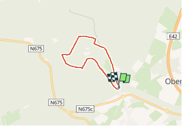
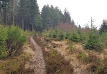
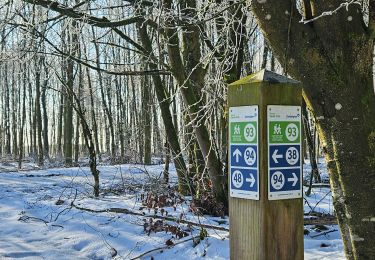
Ruta Senderismo de 4,7 km a descubrir en Valonia, Lieja, Sankt Vith. Esta ruta ha sido propuesta por pierreh01.
Descripción
Dimanche 4 septembre 2022
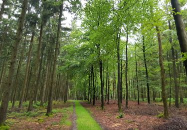
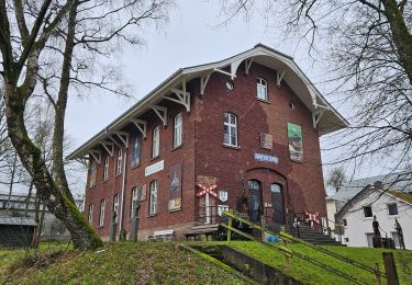
Dans le cadre d'un "cousinage", petite balade apéritive dans les bois à proximité du Biermuseum de Rodt.
Distance mesurée avec SityTrail, semblant plus proche de la réalité.
Localización
País:
Belgium
Región :
Valonia
Departamento/provincia :
Lieja
Municipio :
Sankt Vith
Localidad:
Unknown
Salida:(Dec)
Salida:(UTM)
290761 ; 5575825 (32U) N.
Comentarios
Excursiones cerca
![Excursión Senderismo Sankt Vith - 2022-01-18_14h03m12_st-vith---rodt - Photo](https://media.geolcdn.com/t/375/260/ext.jpg?maxdim=2&url=https%3A%2F%2Fmedia.geolcdn.com%2Ff%2Fd0dd3b78-7ec5-4080-b084-a9f6aaad51fd.jpg)
![Senderismo Senderismo](https://static1.geolcdn.com/sitytour/trail-icons/101.png)
2022-01-18_14h03m12_st-vith---rodt
Senderismo
Fácil
(1)
Sankt Vith,
Valonia,
Lieja,
Belgium
![](/images/other/stat-length.png)
16,1 km | 19,5 km-effort
4h 26min
![](https://static1.geolcdn.com/siteimages/upload/files/16400158638029165_repeat_loop_refresh_sync_direction_icon.png)
Sí
![Excursión Senderismo Sankt Vith - 2021-05-17_18h38m48_recht - Photo](https://media.geolcdn.com/t/375/260/ext.jpg?maxdim=2&url=https%3A%2F%2Fmedia.geolcdn.com%2Ff%2Fdf57db6f-82de-45d3-a1f9-f0242505f9de.jpg)
![Senderismo Senderismo](https://static1.geolcdn.com/sitytour/trail-icons/101.png)
2021-05-17_18h38m48_recht
Senderismo
Fácil
(1)
Sankt Vith,
Valonia,
Lieja,
Belgium
![](/images/other/stat-length.png)
13,3 km | 17,8 km-effort
4h 2min
![](https://static1.geolcdn.com/siteimages/upload/files/16400158638029165_repeat_loop_refresh_sync_direction_icon.png)
Sí
![Excursión Senderismo Sankt Vith - Rodt - Chiens de traineau - Photo](https://media.geolcdn.com/t/375/260/ext.jpg?maxdim=2&url=https%3A%2F%2Fmedia.geolcdn.com%2Ff%2F1e66ffeb-aa18-4dc8-9647-91e8788c7358.jpg)
![Senderismo Senderismo](https://static1.geolcdn.com/sitytour/trail-icons/101.png)
Rodt - Chiens de traineau
Senderismo
Medio
Sankt Vith,
Valonia,
Lieja,
Belgium
![](/images/other/stat-length.png)
8,4 km | 10,6 km-effort
1h 52min
![](https://static1.geolcdn.com/siteimages/upload/files/16400158638029165_repeat_loop_refresh_sync_direction_icon.png)
Sí
![Excursión Senderismo Sankt Vith - 20230103 - TOTEMUS Saint-Vith - 6.7 Km - Photo](https://media.geolcdn.com/t/375/260/ext.jpg?maxdim=2&url=https%3A%2F%2Fmedia.geolcdn.com%2Ff%2F05c4dc1c-0ce8-497a-889e-8103e5332ca7.jpg)
![Senderismo Senderismo](https://static1.geolcdn.com/sitytour/trail-icons/101.png)
20230103 - TOTEMUS Saint-Vith - 6.7 Km
Senderismo
Medio
(1)
Sankt Vith,
Valonia,
Lieja,
Belgium
![](/images/other/stat-length.png)
6,7 km | 8,9 km-effort
2h 7min
![](https://static1.geolcdn.com/siteimages/upload/files/16400158638029165_repeat_loop_refresh_sync_direction_icon.png)
Sí
![Excursión A pie Trois-Ponts - Liaison - Photo](https://media.geolcdn.com/t/375/260/ext.jpg?maxdim=2&url=https%3A%2F%2Fmedia.geolcdn.com%2Ff%2Fe76f3a7b-19a9-4fd4-95e5-f56c159ed203.jpeg)
![A pie A pie](https://static1.geolcdn.com/sitytour/trail-icons/100.png)
![Excursión Senderismo Sankt Vith - 2022-01-18_13h53m42_st-vith - Photo](https://media.geolcdn.com/t/375/260/ext.jpg?maxdim=2&url=https%3A%2F%2Fmedia.geolcdn.com%2Ff%2F7831892f-a4f2-4308-98c6-69c81cc1340b.jpg)
![Senderismo Senderismo](https://static1.geolcdn.com/sitytour/trail-icons/101.png)
2022-01-18_13h53m42_st-vith
Senderismo
Fácil
(1)
Sankt Vith,
Valonia,
Lieja,
Belgium
![](/images/other/stat-length.png)
15,9 km | 20 km-effort
4h 34min
![](https://static1.geolcdn.com/siteimages/upload/files/16400158638029165_repeat_loop_refresh_sync_direction_icon.png)
Sí
![Excursión Senderismo Sankt Vith - Recht 22 km - Photo](https://media.geolcdn.com/t/375/260/ext.jpg?maxdim=2&url=https%3A%2F%2Fmedia.geolcdn.com%2Ff%2Fa9f794ab-d5e8-4cf0-8525-510ce3401da7.jpeg)
![Senderismo Senderismo](https://static1.geolcdn.com/sitytour/trail-icons/101.png)
![Excursión Senderismo Sankt Vith - Recht (n°22) - Photo](https://media.geolcdn.com/t/375/260/ext.jpg?maxdim=2&url=https%3A%2F%2Fmedia.geolcdn.com%2Ff%2Ffa7fdc36-eafc-4a0d-b96f-d279b6b70b1f.jpg)
![Senderismo Senderismo](https://static1.geolcdn.com/sitytour/trail-icons/101.png)
Recht (n°22)
Senderismo
Medio
Sankt Vith,
Valonia,
Lieja,
Belgium
![](/images/other/stat-length.png)
11,8 km | 15,5 km-effort
3h 31min
![](https://static1.geolcdn.com/siteimages/upload/files/16400158638029165_repeat_loop_refresh_sync_direction_icon.png)
Sí
![Excursión Senderismo Vielsalm - Poteau 6 - Photo](https://media.geolcdn.com/t/375/260/ext.jpg?maxdim=2&url=https%3A%2F%2Fstatic1.geolcdn.com%2Fsiteimages%2Fupload%2Ffiles%2F1553511878bg_sport_marche.png)
![Senderismo Senderismo](https://static1.geolcdn.com/sitytour/trail-icons/101.png)
Poteau 6
Senderismo
Medio
(1)
Vielsalm,
Valonia,
Luxemburgo,
Belgium
![](/images/other/stat-length.png)
6,2 km | 7,2 km-effort
1h 38min
![](https://static1.geolcdn.com/siteimages/upload/files/16400158638029165_repeat_loop_refresh_sync_direction_icon.png)
Sí